April closed significantly drier across Illinois. Some areas across Central Illinois witnessed one of their driest Aprils on record and this opened wide planting windows across the state. Busy fieldwork and planting were easy to observe with a short drive across the many fertile croplands of Illinois. Planting progress for soybeans remains above average for early May at 66%. While the drier pattern made for friendly planting conditions, it wasn’t at all sunshine and cotyledons. A few frosts, and even a hard freeze, impacted some agriculturally intensive areas in the middle of the month. Widespread damage and replant were not reported but it was a reminder why the variable nature of April weather makes for so many challenging planting decisions this time of year.
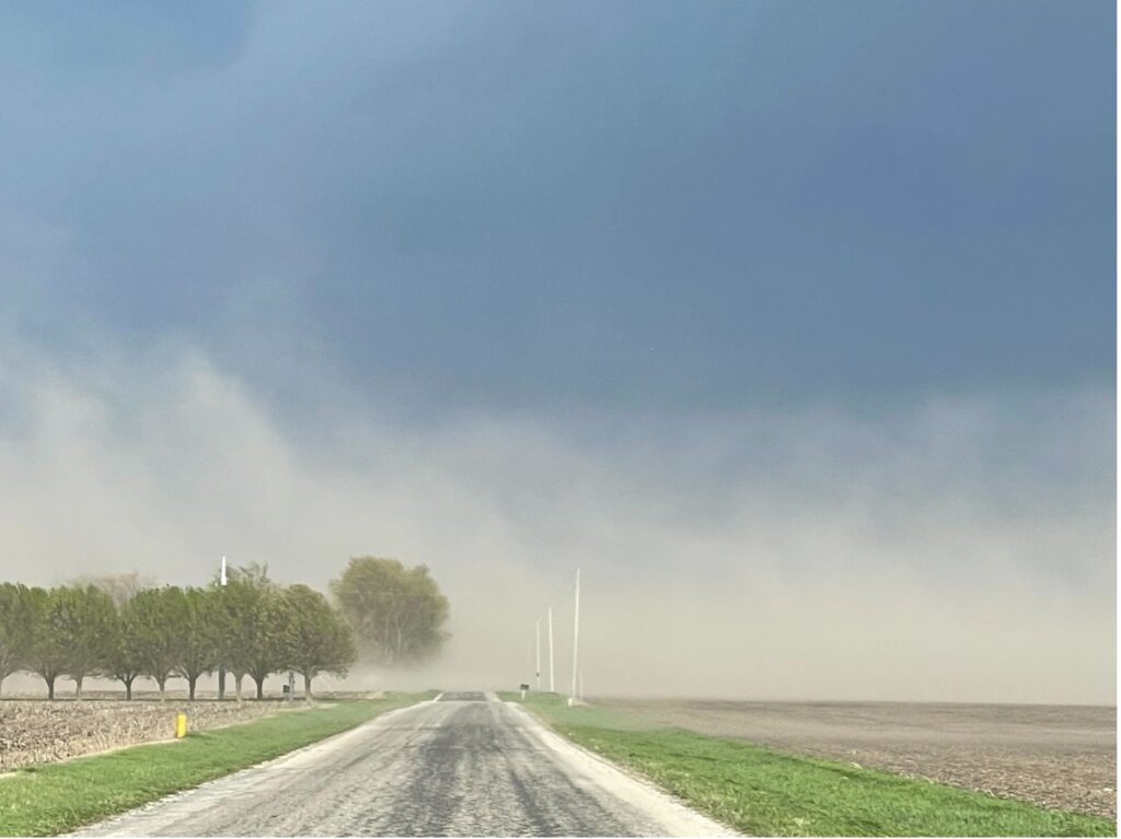
Figure 1: Blowing Dust in Champaign County 4/16/23 – Photo: Andrew Pritchard
The drier conditions observed over the last few weeks briefly reintroduced some drought concerns to the Corn Belt. The High Plains are still in the vice grip of a multi-year drought which had begun to shift east, into the Western Corn Belt, because of the drier April. The latest US Drought Monitor (USDA) shows encroaching areas of drought classifications toward Illinois. Some counties along the Mississippi River are now included in the lowest drought classification – although recent storms will work to remove that. Soil moistures responded to the lack of water in expected ways and a good portion of the Central US breadbasket is now running deficits for early May, which included most of Central Illinois before recent rains. Unfortunately, those drier soils brought about tragic consequences last week when a dust storm caused a fatal pile-up on I-55 south of the Springfield, IL. Localized blowing dust is not uncommon during this time of year, especially when conditions are drier, but strong winds and a particularly treeless and exposed patch of highway led to a tragic intersection of factors.
Showers and storms this past weekend brought much needed moisture to soils across most of Illinois with just a few counties missing out on substantial precipitation. This was just what the doctor ordered and will help to stave off any significant drought development just as it was starting to become a concern. Some thunderstorms were severe, however, with damaging wind and hail reports observed in a handful of counties. Temperatures will remain on the warmer side this week with routine daytime highs near 80F versus the dreary and chilly April weather we experienced the past few weeks. Some shower and thunderstorm activity looks to return to the state next weekend as well, perhaps as early as Friday, May 12th.
Looking further into May, the upper-level ridging responsible for our warmer temperatures this week is forecast to shift west over the Western US by the middle of the month. This will have two effects on Illinois weather: 1) Temperatures will shift more seasonal or average; 2) Drier conditions will be favored through mid-May. That drier forecast is why we were watching these recent weekend storms so closely. Local areas that missed out on significant rainfall could be looking at a longer stretch without meaningful precipitation. Rain chances this coming weekend will be important to capitalize on as well.
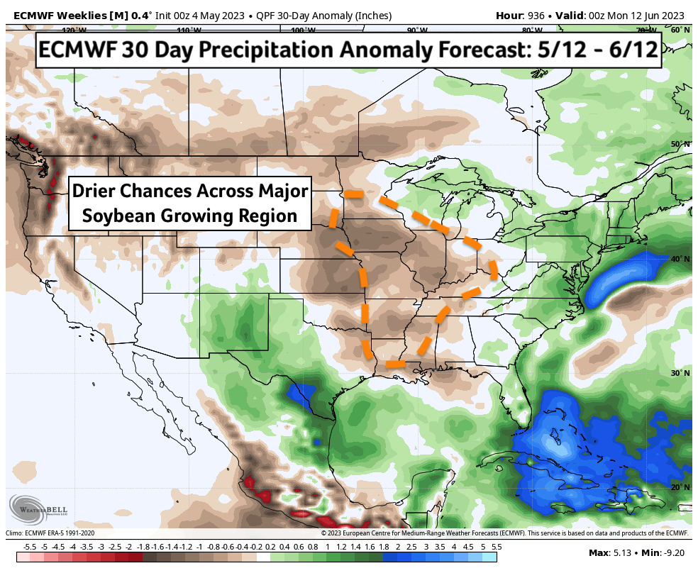
Figure 2: ECMWF 30 Day Precipitation Anomaly Forecast
Sea surface temperatures of the West Coast of the U.S. continue to remain much cooler than average this month. This is a characteristic of what meteorologists call the negative phase of the Pacific Decadal Oscillation (PDO). These ocean temperatures can have downstream effects on the weather all the way over here in Illinois. In fact, colder waters there tend to influence drier conditions in the Central Corn Belt this time of year. Growing seasons started similarly dry in 2022 and 2021 which both featured negative PDO’s. It’s not a big surprise then that we’re also expecting generally drier conditions to continue into first half of June. No two, or three, seasons are the same, however, and this year has a marked difference. Warming ocean temperatures in the Central Pacific have increased the chances for El Niño to a rather significant likelihood by the end of summer. Given most dynamical forecast models develop an El Niño by August, I’d place that probability at 85%. Some of these models, including the reputable Bureau of Meteorology (Australia), are forecasting the development of a near record warm El Niño.
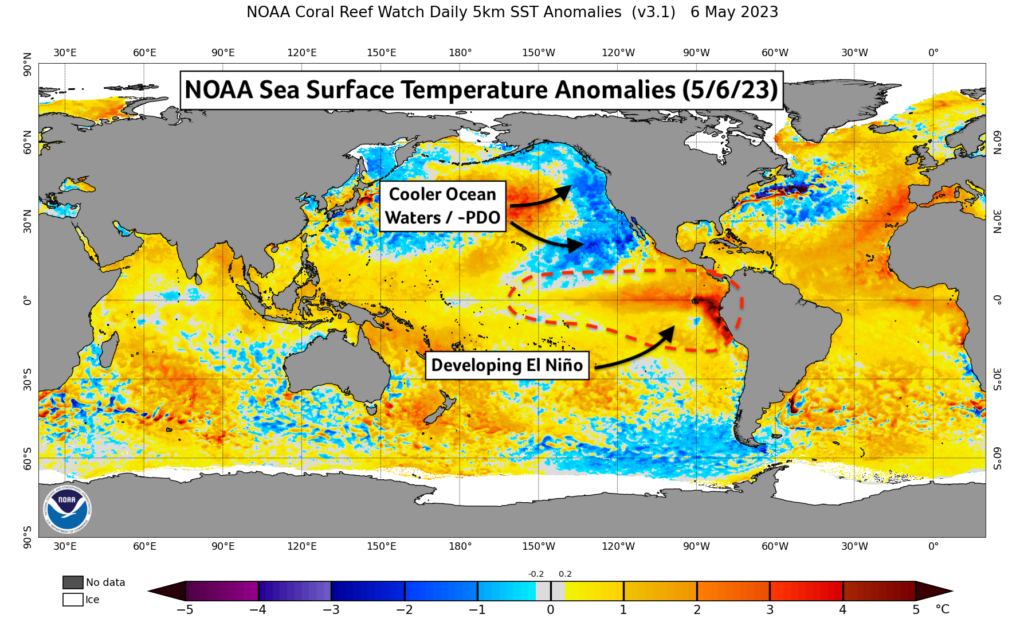
Figure 3: NOAA SST Anomalies (5/6/23)
El Niño is usually a friend to growers in the middle part of the country and that includes Illinois. Warmer ocean temperatures in the Pacific work to nudge and strengthen the Jet Stream in such a way that yields increased summer thunderstorm activity in the Corn Belt. Incidentally, it can also work to erode those cooler ocean temperatures off the West Coast which helps to reduce their dry influence on our weather. Seasonal forecasts from the ECMWF, Europe’s flagship weather prediction model, have consistently depicted just that scenario occurring. Long range forecast models have forecast above average precipitation and seasonal temperatures for the Central Corn Belt through the summer months.
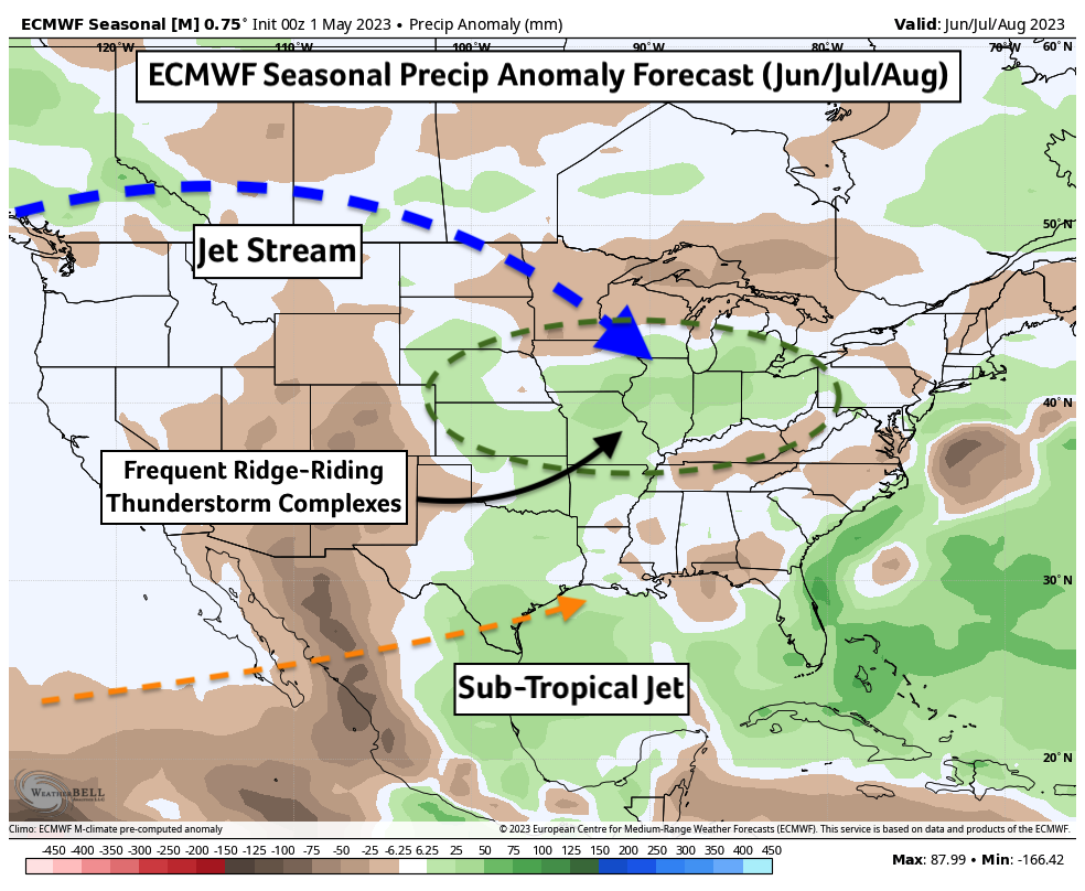
Figure 4: ECMWF Seasonal Precip Anomaly Forecast (Summer)
Complicating this forecast is the timing. Our short-term forecast looks dry, and those colder ocean waters to our west don’t appear to be warming in any immediate future. It’s looking likely that our growing season starts on the drier side, and as El Niño continues to develop, turns wetter at some point in summer. That said, a rogue overnight thunderstorm complex can go a long way toward relieving drought issues — just as we saw this past weekend. The good news is that, if anything, El Niño has been developing ahead of schedule. We haven’t officially entered El Niño status but water temperatures in the Central Pacific are quickly warming this month and that looks to continue through mid-May. The sooner we enter El Niño, the better our chances for seeing those bountiful influences on our weather pattern.
In the meantime, feel free to join me in watching the overnight radar this weekend with an ever-hopeful eye toward the next midnight light show.
About the Author: Matt Reardon


 and then