July rainfall delivered needed relief to drought-stricken crops in Illinois. Many ag intensive counties observed above average rainfall for the month with some areas receiving 6”+. A narrow corridor of below average rainfall was observed along the I-70 corridor in the southern part of the state. However, this area received meaningful precipitation from severe storms over the weekend (8/6). Despite helpful rain, very warm temperatures and high humidity contributed to high heat index days later in July. Beyond that brief spell, heat stress has largely been avoided in what’s otherwise been a mild summer temperature-wise. Crop conditions have improved in the last month and the early trends for August look promising as well — especially for soybeans which are perhaps most dependent on August weather.
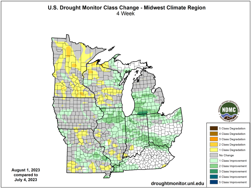
Figure 1 USDA Drought Monitor Change Map (Last 4 Weeks)
The key driver in the recent drought reduction, and wetter August forecast, is the jet-stream. After spending much of June further south across the Gulf States, its retreated north back into the Midwest in July and August. Those fast, upper-level winds have helped to focus storm tracks along the Corn Belt. This has contributed to severe storm activity at times, but it’s also provided valuable summer rainfall to a recovering crop. With upper-level ridging building into the Western U.S., sparking concerns for an active wildfire season in Northwest states, persistent troughing is forecast to linger in the Central U.S. That will work to increase temperatures west while continuing the mild summer locally.
As of this writing, soybean prices have fallen, likely linked to current August forecast trends and recent Midwest rainfall. After rising through the June drought and plateauing in July, made-in-August beans are trending lower. The Climate Prediction Center (CPC) has forecast above average chances for above average precipitation during the third week of August across Illinois and the wider Soybean Belt. That could follow what’s looking to be a rainier week this week here in the second week of the month. Temperatures are expected to remain on the cooler side this week and next with a slight trend toward warmer conditions near the end of the month.
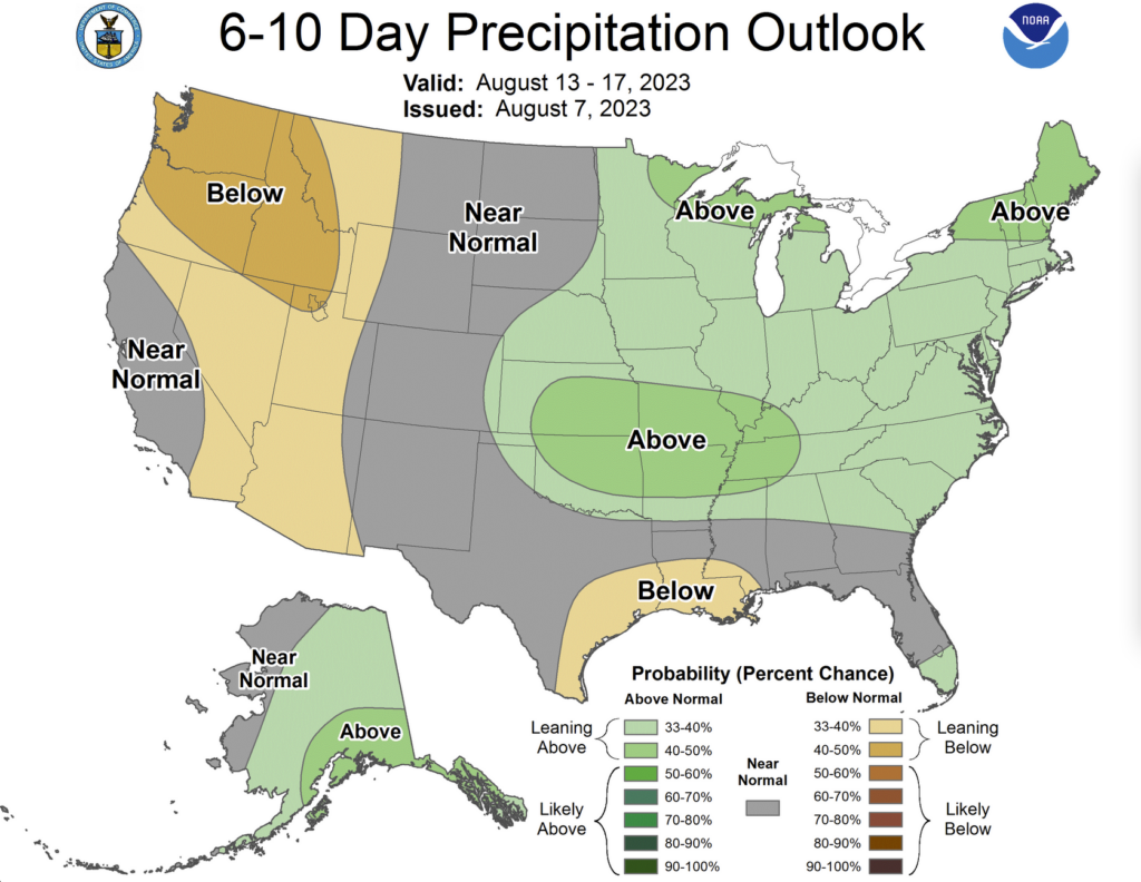
Figure 2 Climate Prediction Center 6-10 Precip Anomaly (8/13 – 8/17)
With the observed early August rainfall and continued rain chances in the forecast, my focus is shifting toward harvest. In preparing my autumn forecasts, much of that focus shifts to El Niño and its development in the Pacific. El Niño has been slow to develop this summer and after a pause in that development in July, water temperatures are warming again in the Central Tropical Pacific. It’s that region of the Earth’s Ocean where we measure ENSO (El Niño Southern Oscillation). Additional strengthening is expected through fall, and we could see particularly strong El Niño peak this winter. In El Nino’s past, we typically observe rainier fall months and wetter harvest conditions. Current seasonal forecasts for these months depict wetter conditions for the Corn Belt – in line with that El Niño climatology. While that does raise an element of concern for soil workability, we know that wet seasons can still possess manageable dry windows if rains fall more episodically.
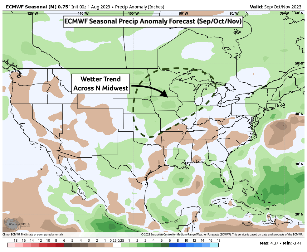
Figure 3 ECMWF Seasonal Precip Anomaly Forecast (Sep/Oct/Nov)
Internationally, Brazil is nearing the start of their planting season in what will be our fall but their spring in the Southern Hemisphere. After August, markets will shift their attention to planting progress in large producing states in Central and Southern Brazil. In the last decade, Brazil has outpaced all other countries in soybean production and their yields have increased as well. Typically, growers there will wait until reliable monsoon rainfall makes for more ideal planting conditions in late September or October. However, current forecasts are shifting drier for Central Brazil during this time. Concern is growing that a delayed start to the monsoon could shorten the growing season and increase crop vulnerabilities or difficulties double cropping after the summer harvest. Those delayed monsoon forecasts are likely influenced by the positive phase of the Atlantic Meridional Mode (+AMM) which manifests as warmer waters in the Tropical Atlantic near Africa. This can weaken important monsoonal winds which bring vital moisture into Central Brazil. That said, forecast trends in more southern regions have trended wetter in contrast – these states have significant production as well. Those warmer Atlantic Ocean waters, serving as a fuel for tropical storms, are also influencing more aggressive forecasts for this Atlantic Hurricane season. I’ll be watching this area closely as it could play an outsized role on grain markets and hurricane activity this fall.
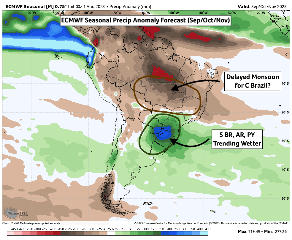
Figure 4 ECMWF Seasonal Precip Anomaly Forecast (Sep/Oct/Nov)
Locally, we still have the bulk of August to contend with before the combines can be dusted off. Should the month end wetter than average, it’s likely that much of that rain will be delivered via thunderstorms. Some of those storms could be severe like we saw this past weekend. A tornado was observed near Taylorville, IL, on Sunday (8/6) that received a preliminary EF2 rating from the National Weather Service – fortunately no serious injuries have been reported at this time. Curiously, Illinois now leads the nation in tornado reports this year. Despite drought earlier in the growing season, a fast start to the severe season in spring and recent severe weather this summer has us ranked first in a competition I didn’t sign-up for. Fortunately, many of these tornadoes have been on the weaker side.
Matt Reardon
matt.reardon@nutrien.com
About the Author: Matt Reardon


 and then