On the morning of March 31st, 2023, the Storm Prediction Center (SPC) issued a high risk for tornadoes in anticipation of a widespread tornado outbreak. This included a wide risk area across Illinois and Iowa. Over the next 24 hours, dozens of tornadoes tracked across the Central U.S. with many reported right here in Illinois – some of which were strong. The current total stands at 123 tornado reports for the event nearing historic levels for late March. Just a few days later, on April 4th, yet another outbreak of severe weather was observed across the state. Large hail was reported across Northern Illinois and the Chicago metro area along with a few tornado reports in Northwest and Central Illinois. Late spring is the climatological peak of the severe weather season in Illinois and storm reports are not uncommon in March and April. That said, such a widespread and impactful outbreak of tornadoes is rare and unfortunately, we’re hardly half-way through that peak window for severe activity.
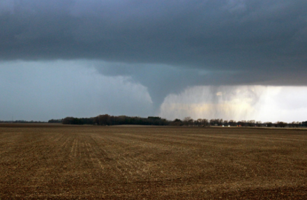
Figure 1: EF2 Tornado near Riverton, IL, 3/31/23 – Jeff Frame
Spring thunderstorms can yield a risk for wind, hail, and tornadoes but with our focus on the severe potential of these storms we occasionally forget their most predictable impact: rain! These spring weather systems, and their many storms, delivered a wet March for Illinois and much of the Corn Belt. Sweeping cold fronts on the backside of these systems kept temperatures below average for the month. As the calendar turned to April, we began to see hints that this cool and wet pattern was beginning to breakdown in the forecast. That’s good news for those seeking planting windows across the state.
March was dominated by deep upper-level troughs anchored across the Western United States. This promoted storm activity, tornado outbreaks, and those pesky cold fronts across the Midwest. That persistent troughing has already begun to whither as of this writing (April 7th) and is being replaced by an upper-level ridge. Ridges in the upper atmosphere tend to promote warmer and drier conditions at the surface and that’s consistent with the forecast for the Western US during the week of April 9th – 11th. That ridging, along with the warmth, will shift eastward in time such that by Wednesday, April 12th, that ridge is centered over the Midwest. It’s not a surprise then to see high temperatures forecast in the upper 70’s and lower 80’s across Illinoi by mid-week. Just as important, is the influence that ridge will have on rainfall. Drier conditions are forecast for the Central Corn Belt next week and it’s looking increasingly likely that this pattern could stick around through mid-month. Soil temperatures are forecast to rise during this time and planting windows will open in earnest across the Central Corn-Belt.
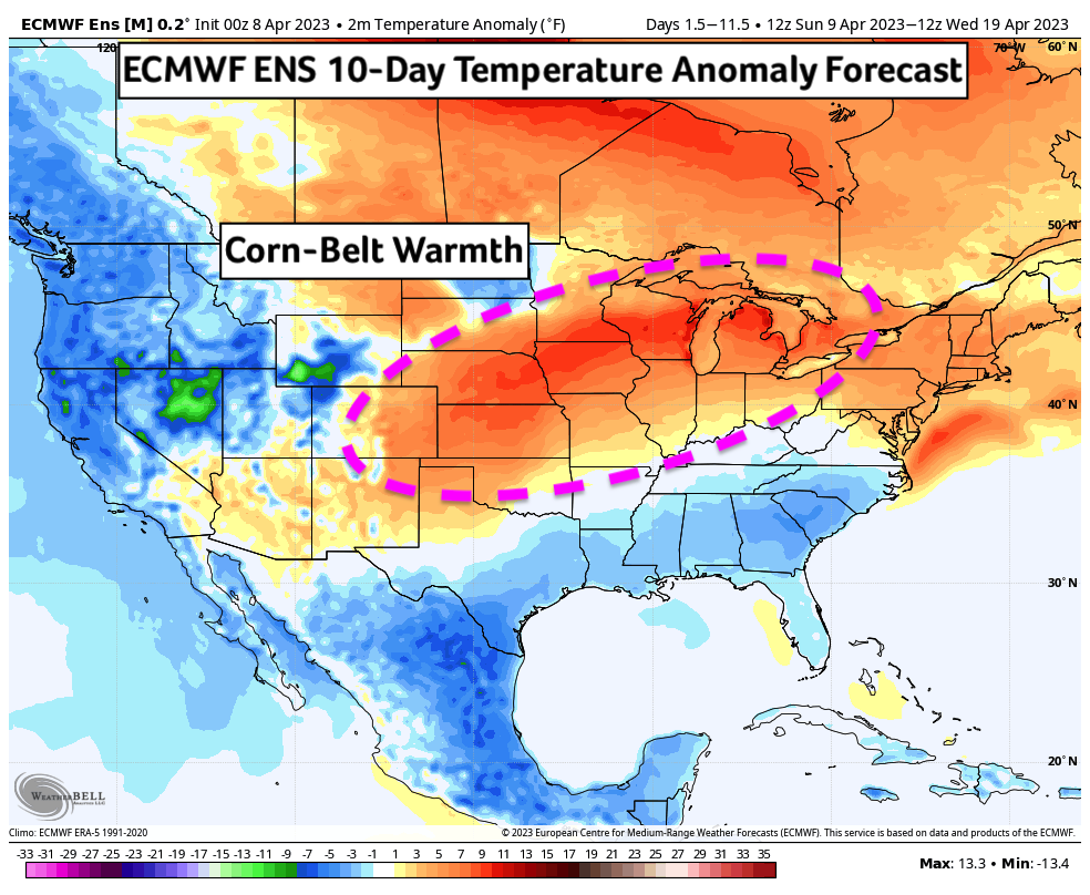
Figure 2: ECMWF 10-Day Temperature Anomaly Forecast (4/9 – 4/19)
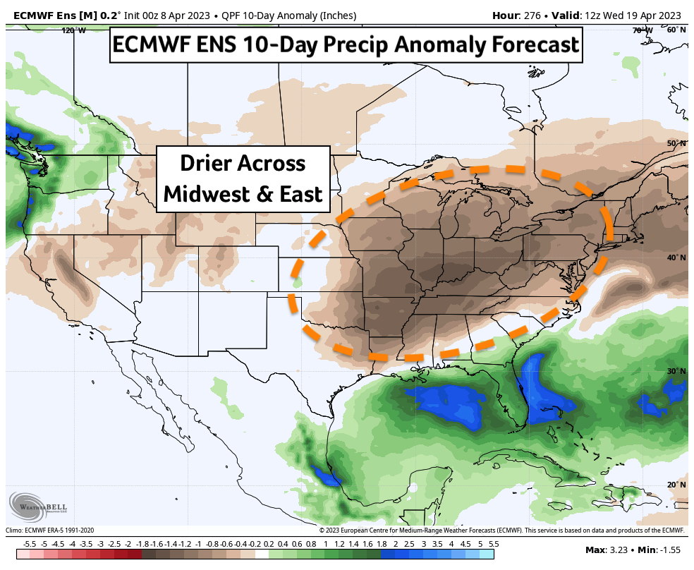
Figure 3: ECMWF Precipitation Anomaly Forecast (4/9 – 4/19)
Forecast uncertainty exists when determining how long this dry pattern will last. A pattern change appears evident at some point in late April. Long range forecast models have suggested that the anomalously warm temperatures will trend more seasonal to end the month. Whether this pattern change is accompanied by increased precipitation in the last week of April is unclear. One tool we use to forecast weeks in advance is the Madden-Julian Oscillation (MJO). This circulation slowly traverses the tropical regions of our oceans affecting convective patterns near the equator – these, in turn, can have influence on our weather through their effects on the Jet Stream. The MJO is currently moving through the Western Pacific where, historically, it has promoted warmer and drier conditions across the Central US. That’s consistent with our forecast this week. As we move through April, the MJO is forecast to transition toward the Eastern Pacific which could influence a pattern change toward more seasonal temperatures and perhaps more average precipitation across Illinois.
Beyond April, our attention turns towards Earth’s oceans for clues into the summer forecast. Earlier this spring, we transitioned of that drought inducing La Niña state in the Pacific into neutral conditions. Global forecast models, which attempt to predict changes to ocean temperatures months in advance, have suggested a strong likelihood that we enter El Niño this sometime this summer. The ECMWF (European weather model) and the Bureau of Meteorology (Australia’s weather service) are two of our most reliable predictors of ENSO (El Niño Southern Oscillation) – enough with acronyms! Both models have called for a rapid transition to El Niño by August. Warmer ocean temperatures across the tropical Pacific Ocean (El Niño!) in summer historically promote increased rainfall across the Central US, benefitting growers in the Corn Belt. No forecast model is perfect, however, and while chances are high for a transition to El Niño, they aren’t 100%. It’s also possible we transition to El Niño more slowly toward the end of the growing season which could see us miss out on that timely rainfall influence. We will be watching this transition closely over the next few months to determine what sort of growing season we will have. At least for now, long-range precipitation forecasts for Illinois this summer suggest an increased chance for rainfall which this meteorologist agrees with. Temperatures are also trending more seasonal which would reduce the risk of intense heat-waves and flash droughts.
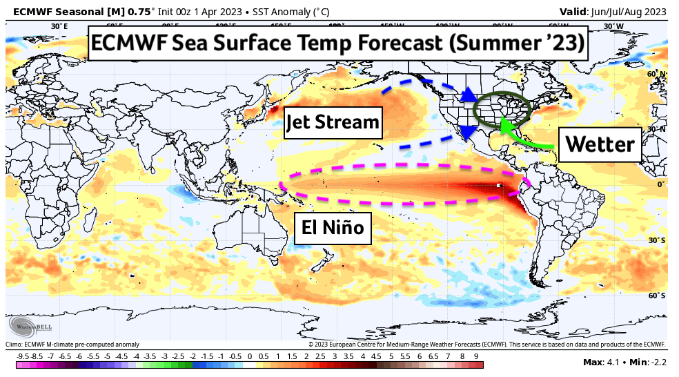
Figure 4: ECMWF Sea Surface Temperature Anomaly Forecast (June-July-August)
Internationally, South America is harvesting two very different soybean crops in what is now their Autumn. In the South, Argentina experienced crippling drought during their growing season which has produced meager yields. On the other hand, Brazil received bountiful rains during their summer (our winter) months and are harvesting a bumper crop. Brazil’s increased production and yield could be enough to offset the losses in the South. This north/south pattern of a wet/dry growing season is consistent with the La Niña influence they experienced in their growing months. Should we remain in an El Niño through their next growing season (‘23/’24) that pattern could reverse. In the Northern Hemisphere, India and China will be planting their soybean crop soon and the former could see reduced Monsoon activity this summer should the forecast El Niño verify. Drought will be a concern. The story in China is more mixed with less of precipitation signal in either direction. Drought concerns extend to Europe as well where a lack of winter snowfall and a drier summer forecast has some concerned. That said, large soybean producing nations in the South and East are largely excluded from this drier forecast area for now.
As for tornadoes back home, just as we discussed the connection between strong storms and rainfall, we would also expect a lull in severe activity as we work our way through this drier pattern in April. May is just as active as a month historically, however, and I’m confident we will, once again, be tracking severe weather in May. This is Illinois after all!
Matt Reardon
matt.reardon@nutrien.com
About the Author: Matt Reardon


 and then