I’ve tried to avoid looking at my lawn since mid-March when temperatures warmed up locally. Sure, I know it’s growing and the push lawnmower in my shed, which I have stubbornly refused to upgrade for years, beckons. Not coincidentally, root zone soil temperatures surpassed the 50°F threshold around that time. Our soils are waking up across the state and with that field work and planting is now top of mind for growers. USDA’s latest Crop Progress report shows one percent of the state is planted for corn and soybeans.
The median last frost date in Illinois ranges from late April in northern counties to early April in the south. Hard freeze median dates run a week or two earlier depending on the county (see the Illinois State Water Survey maps below). A common concern I’ve heard this spring surrounds the chances for a late freeze like we saw last April. Virtually the entire state experienced a late freeze the week of April 24th, 2023. Areas as far south as I-72 observed hard freezes that morning with some young crops seeing injury.
Cooler temperatures continue this week with nightly frosts having returned to the state. Low temperatures are expected to bottom out this Saturday, April 6th, with a hard freeze likely north of I-74. Fortunately, the long-range forecasts shift warmer next week which will lower frost chances through mid-April. The weather pattern required to plunge the state into a late April frost would not be within the reliable range of accurate weather forecasting at the time of this writing. Further, last year’s April temperatures in the state ended average to above average despite the observed freeze!
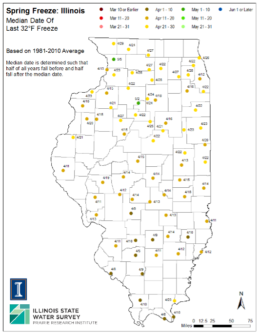
Figure 1: Illinois State Water Survey 40yr Median Frost Date
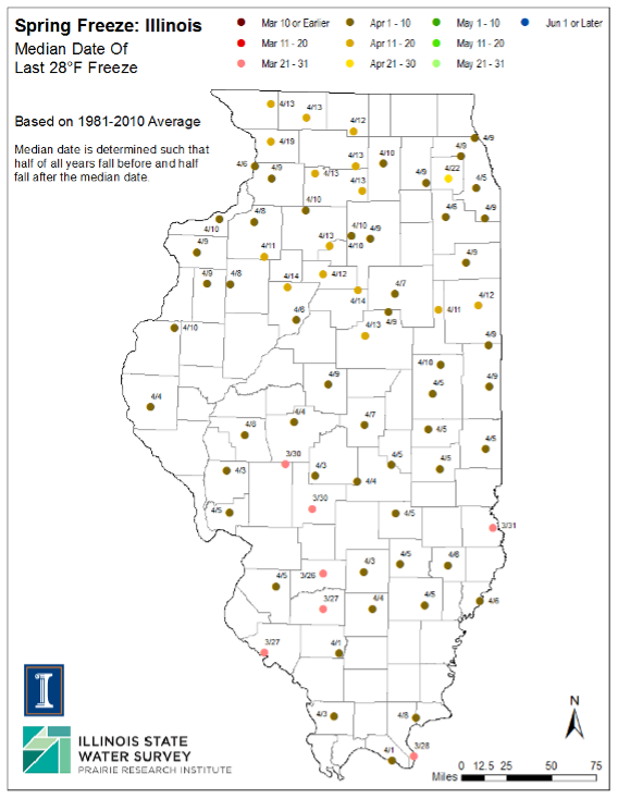
Figure 2: Illinois State Water Survey Median 40yr Spring Hard Freeze Date
Last weekend, a strong supercell thunderstorm left a swath of golf ball sized hail reports through Central Illinois with more considerable damage reported in Decatur, IL, and Macon County. That continues a busy spring severe weather season for the state. Severe storm activity typically peaks in April and May and seasonal forecasts suggest this year could see greater severe thunderstorm activity in the Corn Belt. That said, this week’s cold temperatures will coincide with reduced storm chances until next week’s warmup.
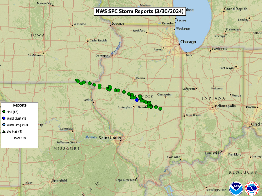
Figure 3: SPC Storm Reports (3/30/2024)
Spring and summer storms also yield rainfall and moisture remains a focus as we move through this year’s plant. Lingering soil moisture deficits are still evident across the central Corn Belt in early April due to a warm and dry winter with little snow. Recent rains, with more likely next week, have improved these. Drought classifications exist in far western Illinois and across much of Iowa, Wisconsin, and Minnesota. Long range forecasts for April suggest a continuation of routine rainfall chances which could coincide with renewed severe weather activity.
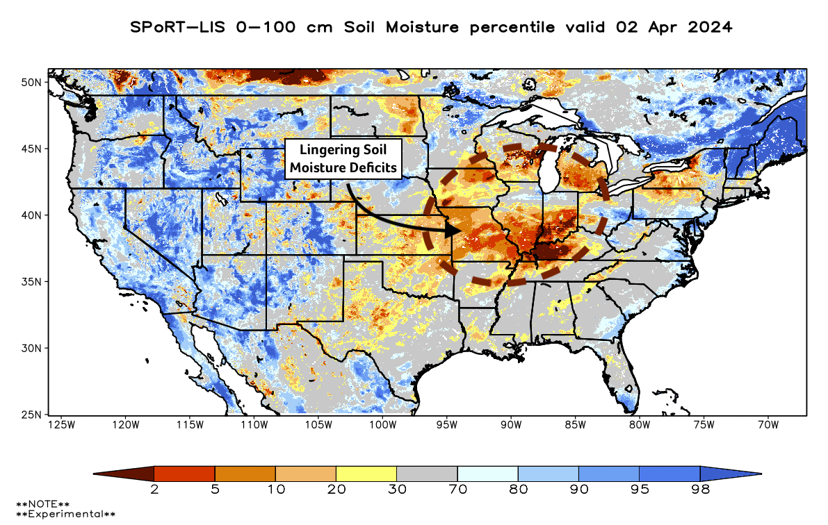
Figure 4: NASA Sport 0-100cm Soil Moisture Percentile
In the Pacific, El Niño continues to weaken. El Niño, which is classified by warmer sea surface temperatures in the central tropical Pacific, peaked last winter around the holidays. El Niño is likely responsible for the warm and dry winter across the Upper Midwest. El Niño is likely to weaken to neutral or even La Niña through this upcoming growing season. This transition could influence summer rains across the Central US and Illinois. When averaging rainfall across previous summers (June, July, and August) with a similar El Niño to La Niña transition, I found increased rainfall anomalies across the central Corn Belt during summer months. That said, La Niña is correlated with increased drought risk in the Central US and a faster transition than currently forecast could increase that risk later in the growing season. That scenario would pose a greater risk for soybeans with its dependency on August rains.
Seasonal precipitation forecasts are consistent with our understanding of past transition years. The ECMWF, which has a slower transition to La Niña, has forecast increased rains for the Soybean Belt this summer (see forecast below). It also highlights two areas of increased drought concern: the Western Corn Belt and Southern US. At least for now, improved spring rains and seasonal forecasts suggest reduced drought concern for Illinois and paints an aggregable picture for the season ahead. That said, seasonal forecasting is still very much an inexact science. A faster La Niña transition could require an update to this forecast.
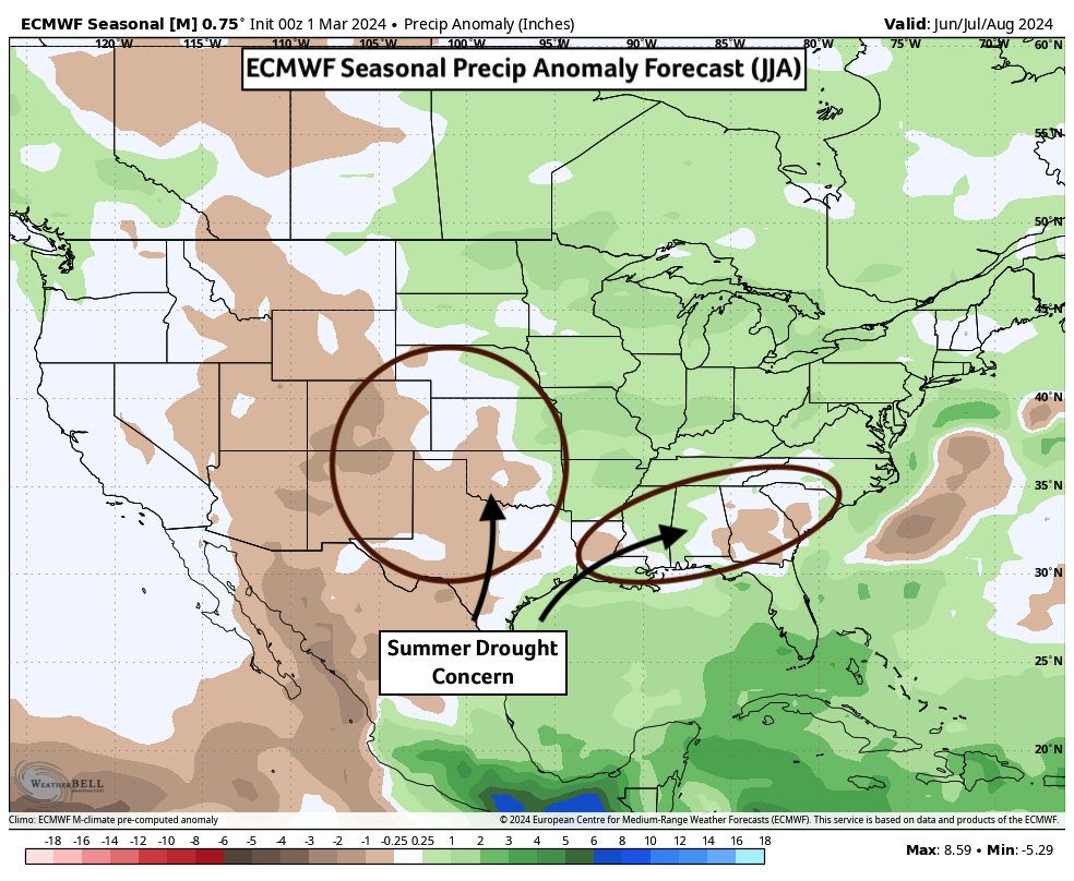
Figure 5: ECMWF Seasonal Precip Forecast (Summer)
This coming Monday (April 8th) will see the 2024 Total Solar Eclipse. It’s path of totality (the phenomenon worth seeing!) will traverse Southern Illinois around 2:00pm (CDT). Cloud cover forecasts are mixed at this time as a low-pressure system is forecast to track through the Central US early next week. A clearer picture of the cloud cover forecast should be available by the weekend. If possible, I strongly strongly recommend making the drive, safely, to view this cosmic phenomenon. It’s truly a once-in-a-lifetime experience and the Contiguous US will have to wait another 20 years (August 2044) for the next opportunity to witness it.
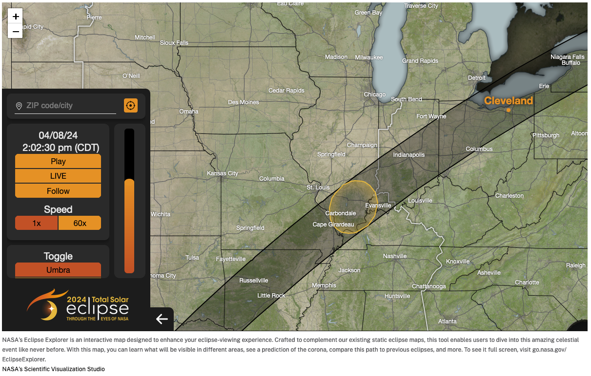
Figure 6: NASA Total Eclipse Path of Totality – Midwest
The cold temperatures this week should slow my lawn growth some which might buy me another week without lawn care. While it seems that renewed warmth and rains will force my hand next week, that’s preferable to the opposite scenario. I went nearly a month without mowing in May last year due to drought.
About the Author: Matt Reardon


 and then