Harvest is wrapping up across the state. The consensus, thus far, is that yields have exceeded expectations despite early season drought. Recent fall rains did delay harvest for some, particularly across northern Illinois. A silver lining: widespread rainfall across the Upper Midwest and other states rebounded critically low Mississippi River levels. Barge traffic delays had become a real concern before this. The USGS river gauge in Memphis, TN, is now 7ft above the lows reached in mid-October. That situation is expected to further improve this month with rainfall forecasts trending positive for the watershed through November.
Very cold temperatures at the turn of the month brought us our first widespread freeze across much of the state. Stations in northern Illinois recorded temperatures near 20F. However, in recent days, temperatures have rebounded significantly. On November 8th, the Illinois State Water Survey station in Champaign-Urbana reached a high of 79°F breaking a daily record at the site and nearly tying the November record (80°F). These temperature swings are reflected in soil temperature data which has root-zone (4”) soil temperatures fluctuating wildly in the early half of the month. With above normal air temperatures forecast next week, we’ll be keeping a close eye on critical soil temperature thresholds (e.g. 50°F) which are important for post-harvest applications.
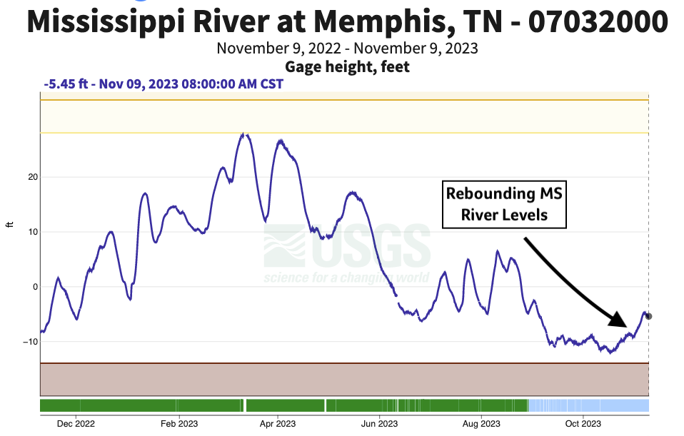
Figure 1: MS River Levels at USGS Station Memphis, TN
The forecast this week suggests more pleasant weather ahead through the work week. A potent upper-level trough, and associated low-pressure system, is forecast to come onshore mid-week in California. A significant rain event could be materializing for the West Coast. From there, as is often the case, that trough is expected to cross the Continental US yielding warmer conditions to through the work week in Illinois. It looks increasingly likely that a cold front will pass through the state Friday clearing out that warmer airmass. Scattered rain showers are possible Friday as a result, but current forecast amounts are not heavy. Eventually, that West Coast low-pressure system will follow yielding rain chances across the Middle MS River Valley early next week. It’s unclear which areas will see the most measurable rainfall from this system, but Illinois is well positioned to get meaningful rain through the 11/18 – 11/22 time period.
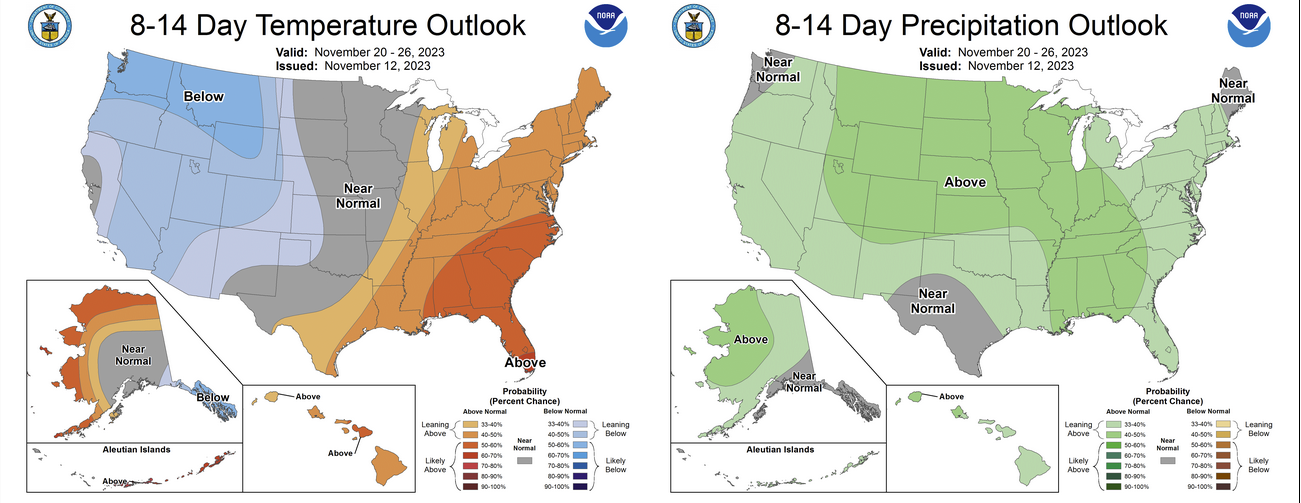
Figure 2: Climate Prediction Center 8-14 Temperature and Precip Outlook
Beyond our immediate weather in Illinois, El Niño continues to strengthen in Pacific. Historically, we tend to see warmer winters in the Upper-Midwest during El Niño. That is consistent with forecasts from the Climate Prediction Center and ECMWF which advertise warmer conditions in northern states through February with a slightly drier forecast overlapping those areas. Those historical connections with El Niño aren’t as strong in Illinois and seasonal forecasts are suggesting a more average winter, if anything, for the state. I wouldn’t read too much into those, however. While La Niña tends to be a little better at producing big winter’s locally, we can still see serious winter chill/snow under El Niño conditions. Of course, It only takes a few big storms to define a winter.
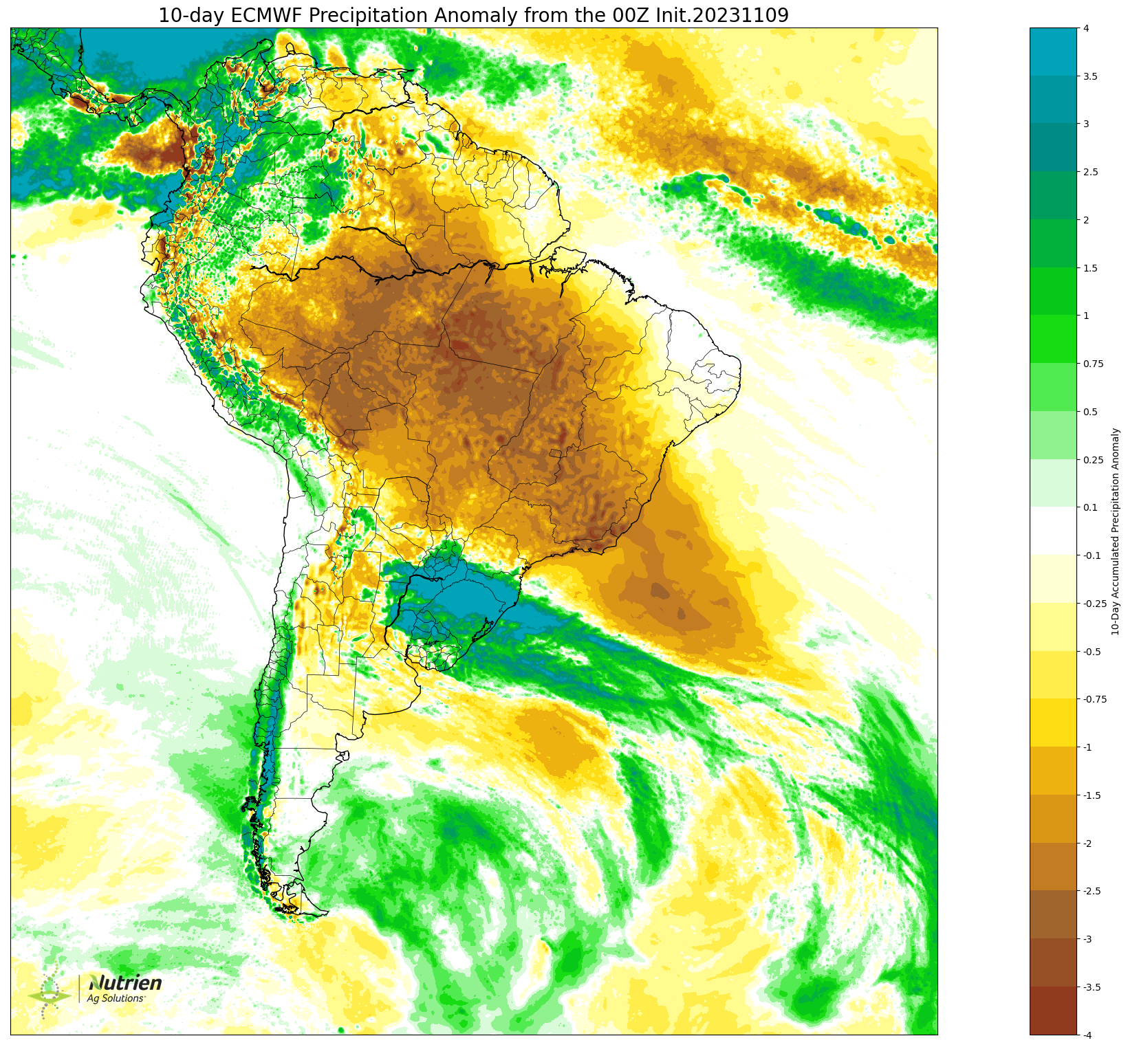
Figure 3: ECMWF 10-Day Precip Anomaly Forecast
Our growing season has come to an end in Illinois but its only getting started in South America. Brazil, the world’s largest exporter of soybeans, is having early concerns with drought. Large soybean producing states in Central and West Brazil have shifted significantly drier over the last few weeks just as crops have begun to emerge. Much like our own early season concerns, it’s hard to know what effect this may on final production, but we know that critical rains later in the season can erase much of those early season issues. That said, forecasts suggest a continuation of that drier trend and temperatures are trending hotter there as well. It’s possible these changes to the forecast in Brazil have played into volatile grain markets in recent days. In Southern Brazil, conditions have been significantly wetter than normal, in stark contrast to states north. Not only have growers there battled excess rainfall but severe weather as well with widespread storm reports including hail, wind, and even a few tornadoes. As for the drought in the major soybean producing states in Central Brazil, I’ll be watching forecasts closely over the coming weeks to see if the mid-season monsoonal rains materialize. This has the potential to become a bigger story if the dry forecasts continue to verify toward the new year.
About the Author: Matt Reardon


 and then