As an Illinois resident, you’ll often find me traveling our interstate highways toward my next destination. Whether it’s for work, field-days, visiting friends, family, or even chasing a picturesque Illinois storm across the state, I’ve tallied my share of miles. Despite this, I made the rather silly mistake of taking a more scenic route to Chicago last month – avoiding the busy interstates for state highways and more intimate views of our bucolic landscapes. I spent much of that drive traveling 6mph behind harvesters. Even the meteorologist forgets his umbrella from time-to-time. It wasn’t for all for naught, however. I witnessed first-hand just how quickly harvest had progressed across the state. Harvesters, grain carts, and trailers could be seen carving up most fields in recent weeks. USDA Crop Progress report confirmed soybean harvest was on schedule through September despite concerns for a delayed start just a few weeks ago.
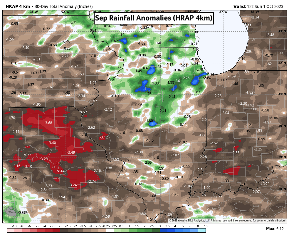
Figure 1) Sep Rainfall Anomalies (HRAP 4km)
Northern counties saw a greater share of rainfall last month with much of that falling in the second half. Acreage in the western and southern portions of the state saw drier conditions and wide-open harvest windows for those starting early. Rainfall across the wider Mississippi River Watershed was scattered at best. Concerns surrounding low river levels and shipment limitations remain in October. There is some good news in the short-term forecast – for the river at least. A low-pressure system forecast to track across the Midwest at the end of this week is expected to bring widespread rainfall to the Upper Mississippi River Valley. Illinois is poised to receive rainfall from this system with higher amounts expected in the northern half of the state. Long-range forecasts suggest another late week rain maker pushing into the Midwest next week. Unfortunately, the river itself may need to wait until more frequent November rain events to truly recover.
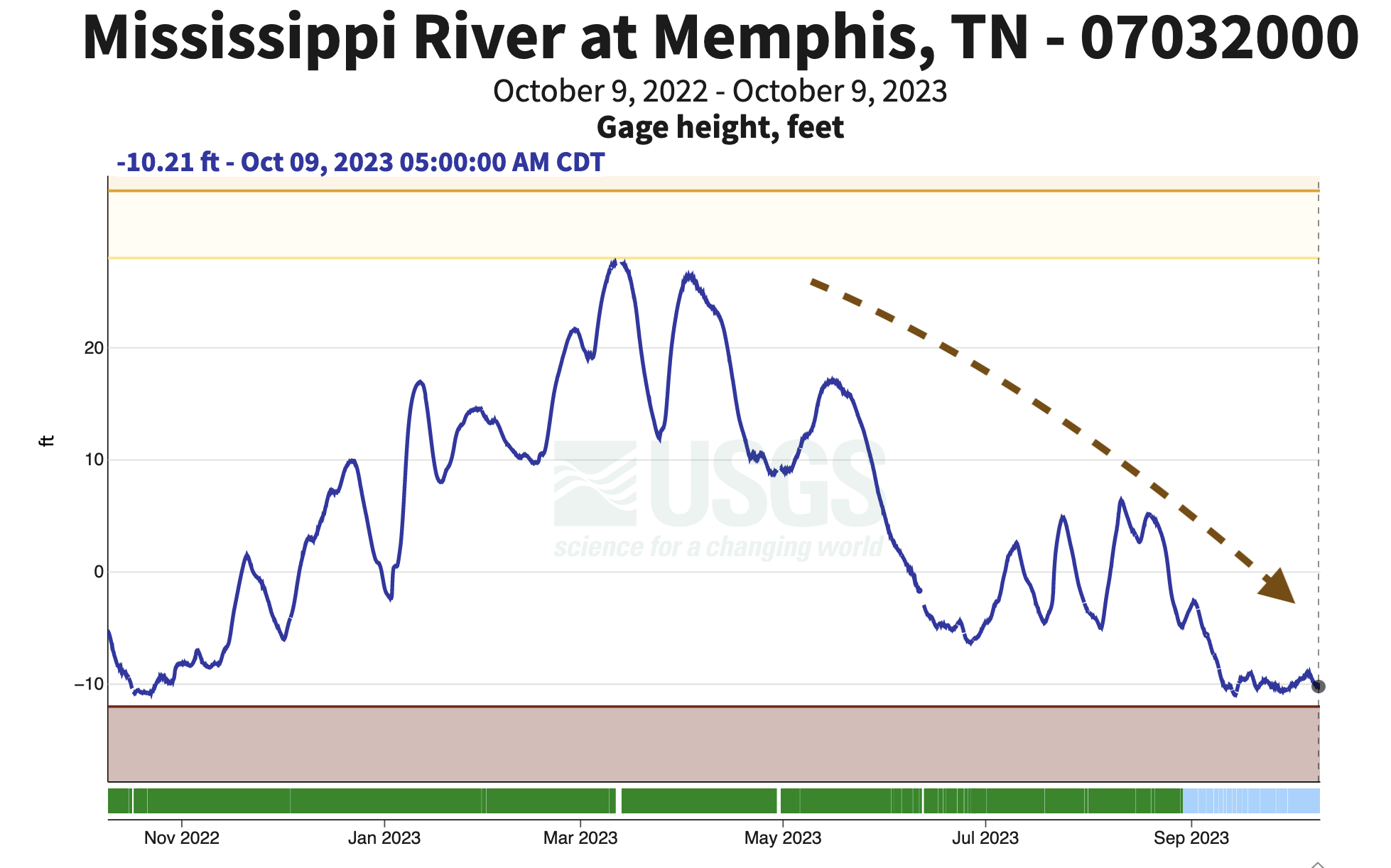
Figure 2) MS River Levels 10/9/23 – Memphis, TN
Temperatures have warmed briefly advance of the rainfall this week but will quickly swing cooler after this weekend. Some counties experienced patchy frost earlier this week with overnight lows dropping into the mid 30Fs. Next week’s forecast suggests overnight lows in the high 30Fs and low 40Fs on Tuesday and Wednesday which would reintroduce frost potential. I can’t rule out a freeze event if this autumn airmass trends colder through the weekend, but I wouldn’t consider it likely at this time. We are quickly approaching or exceeding the climatological average for first frost dates at many sites across Illinois as the season ends.
Much further south in the tropics, El Niño continues to strengthen in the central Pacific. Dynamical forecast models suggest El Niño will peak sometime around December as a moderate to strong event. We’ve been tracking the influence of this climate teleconnection for much of the summer and fall. El Niño autumns tend to produce more frequent precipitation events across the Midwest which bodes well for the recovery of the Mississippi river going forward. Satisfactory soil moisture will also be important for post-season fertilizer applications – assuming it’s not too wet. It hasn’t been a wet fall thus far, but that could change come November using El Niño’s influence as a guide.
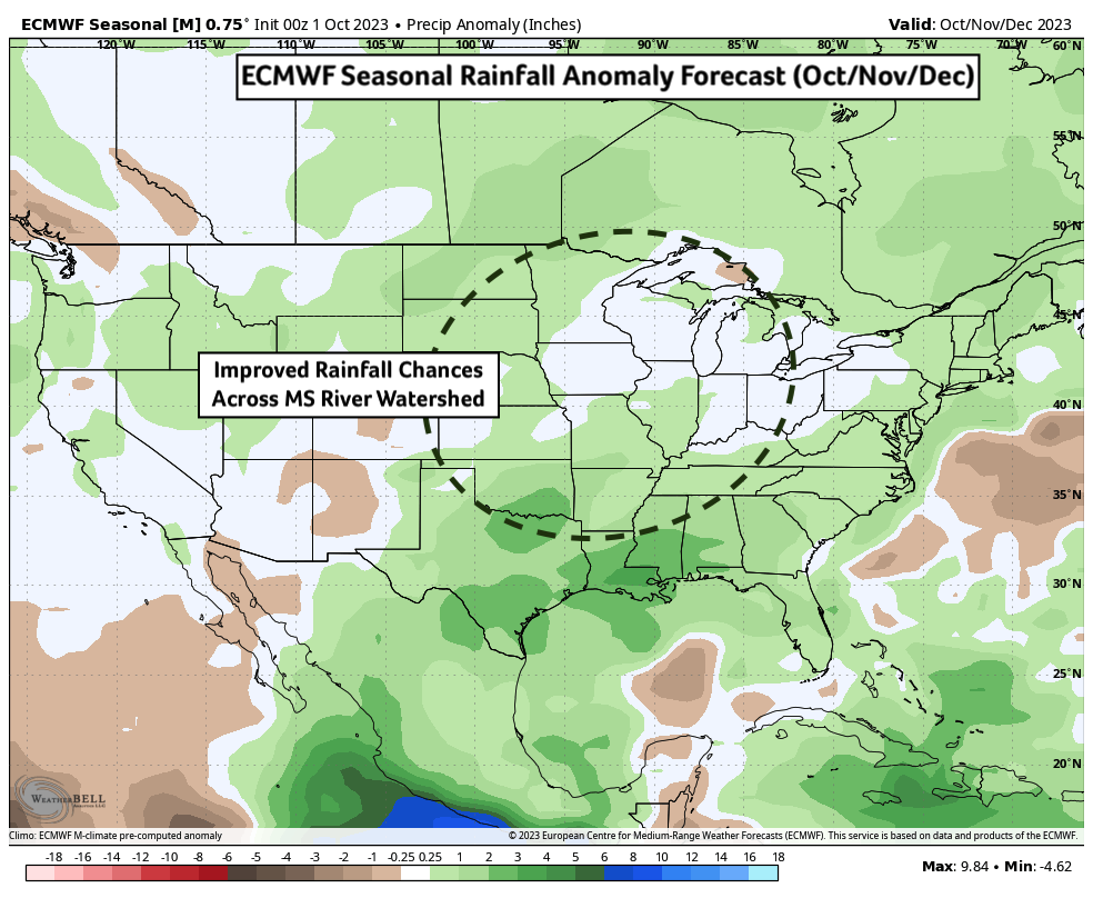
Figure 3) ECMWF Seasonal Precipitation Anomaly Forecast (Oct/Nov/Dec)
Beyond that, there is less certainty surrounding our winter forecast. Given temperature data from El Niño’s past, we’d expect better chances for above average temperatures across the Upper Midwest and portions of Illinois. Seasonal forecasts from the ECMWF, Columbia Climate School’s IRI, and others suggest more neutral temperatures and precipitation this winter for Illinois. NOAA’s Climate Prediction Center (CPC) forecast has slightly above average chances for warmer temperatures with more average rainfall.
About the Author: Matt Reardon


 and then